
The mountain measured the atmosphere before it measured the cosmos, and it never stopped. From the actinometer Ismael Escobar installed in September 1942 to the World Meteorological Organization's Global Atmosphere Watch station operating today at 5,240 metres, there are eighty years of records taken from the same point. In between: ozone, two thousand radiosonde flights, the detection of a French bomb in the Sahara, and a glacier that vanished in 2009.
Why this milestone is different from the others
The eight preceding milestones deal with what arrives from outside the atmosphere: particles produced at astronomical distances that cross the air and reach the detector. This one deals with the air itself.
And there is an asymmetry worth stating out loud: the atmosphere came first. The Chacaltaya station was installed in September 1942 as a weather station, measuring solar radiation, ten years before the Cosmic Ray Laboratory existed (milestone 01). The cosmos came afterwards.
That makes Chacaltaya a site with a double reading: it records the cosmos and the climate at once. For a UNESCO nomination this is a considerable advantage, because the second argument is contemporary and verifiable today, with the station in operation, whereas much of the first is historical.
The original partner: the Servicio Meteorológico de Bolivia
For twenty-three years the Laboratory shared the mountain with the body that had opened it. The Servicio Meteorológico de Bolivia (Bolivian Meteorological Service) obtained surface data at Chacaltaya until 1965.
Aguirre records its departure in a sentence worth keeping exactly as it stands (translated from the Spanish):
"With its departure, the Laboratory loses its original partner in the scientific adventure begun in 1943."
Twenty-three years of surface meteorological data at 5,200 metres, between 1942 and 1965. Locating that series is one of the most valuable archive tasks in the whole project: see §14.
Ozone
In the 1960s the Laboratory moved into other areas of physics, and the first was atmospheric ozone.
The occasion was the International Year of the Quiet Sun (1965) — the counterpart, at solar minimum, of the International Geophysical Year of 1957 (milestone 08). Ramón H. Schulczewski, "with the determination that always distinguished him", took charge of the experiment together with Fernando Sheriph, who years later would hold an important post at Université Laval in Quebec. The technicians Dardo Beramendi, Velasco and Rocha took part.
And there was one exceptional moment of observation. During the total solar eclipse of 12 November 1966, Schulczewski and Sheriph measured ozone profiles and upper-level winds. With the support of the Armed Forces and the work of Max Schreier, Ángel García Ontiveros, Gastón Mejía Brown and Israel Saravia, the observations and their analysis "had important repercussions in the international community".
Measuring ozone during a total eclipse, from 5,200 metres, is an opportunity that comes once.
3.1 · And how it was lost
Here the milestone carries a wound, and the site must tell it.
Between 1969 and 1971, in a period made difficult by the political situation inside the University and outside it in the country, several projects were closed. Among them the ionosphere project and the ozone project. Aguirre explains what happened to the latter and does not hide what he thinks of it:
"The ozone project was transferred on the instruction of the United States Air Force to the Bolivian Air Force. There it lasted a short time and was closed for good. This transfer was regrettable, since it broke the continuity of work on a subject of enormous current importance in which Bolivia was acquiring great experience. The understanding between air forces prevailed over scientific rationality."
Editorial note. I recommend publishing this passage in full and with the quotation verbatim. Bolivia was measuring stratospheric ozone in the 1960s, more than a decade before the hole in the ozone layer became a worldwide concern. That this series was interrupted by an administrative decision between two air forces is exactly the kind of loss a heritage dossier should document: it explains why the continuity of a scientific site has value, and what it costs to break it. A site that recounts only its successes is less convincing.
Two thousand radiosonde flights
The radiosonde sounding station, installed first at Ovejuyo and later at El Alto airport, made 2,000 flights over an interval of seven years. As a result, the profiles of the upper atmosphere over Bolivia were published for the first time.
It was a joint project of three parties:
| Institution | Country / scope |
|---|---|
| Office of Research of the United States Air Force | United States |
| World Meteorological Organization | United Nations |
| Universidad Mayor de San Andrés | Bolivia |
The results of the daily flights were sent to the Miami Hurricane Center and to the project participants. Locally they were distributed to the Bolivian Air Force through the AASANA network.
And a story the site must tell. Some of the sondes fell in remote places, "causing panic among the campesinos at the arrival of objects 'containing enormous danger'; in many cases these were taken to be of extraterrestrial origin".
It deserves to be told with care and with respect — not as an anecdote of superiority — because it says something real about what it meant to do frontier science on the Altiplano: the instruments were falling literally on communities that had been told nothing. It is also, if one chooses to see it that way, a precedent for why a contemporary scientific project must talk to the communities around it. And it is an open line of research: those stories are still alive in the oral memory of the Altiplano communities.
The bomb in the Sahara
From 1956 onwards the Laboratory ceased to serve cosmic radiation alone. Among the equipment that arrived:
- A medical team from the Donner Laboratory of the University of California, and Drs Herman Templin and William Talber of the US Naval Ordinance Laboratory, installed apparatus to measure the infrared component of solar radiation at altitude.
- The US Naval Research Laboratory installed equipment to measure atmospheric radioactivity. And with it, this happened:
The first French nuclear explosion in the Sahara desert was detected.
France carried out its first nuclear test — Gerboise Bleue — at Reggane, in the Algerian Sahara, on 13 February 1960 ⚠. The instruments at Chacaltaya, at 5,200 metres in the Andes, registered it.
And there was a result of the Laboratory's own that came out of it. In 1962, John Bland — the same man who transistorised the old neutron monitor — measured atmospheric radioactivity and showed the existence of a seven-day delay in the rise of radioactivity in Bolivia after the nuclear explosions.
For the dossier. This passage supplies something no other milestone supplies: a physical demonstration, dated and with political consequences, that this point on Earth is a good place from which to watch the atmosphere of the whole planet. It is not a brochure claim: it is the same argument that sustains, sixty years later, the GAW station. The continuity between 1960 and today is not rhetorical, it is instrumental.
The neutron monitor and the solar–terrestrial line
It is the longest and most continuous instrumental series at the site after the meteorological one.
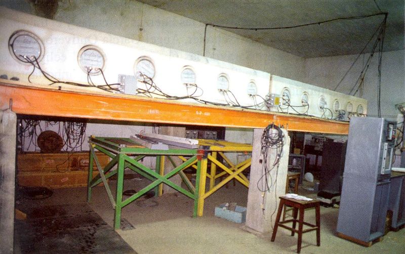
- First, a Simpson-type neutron monitor to measure temporal variations in cosmic radiation. Working with it and with its successor were the physicists Ricardo Anda, Nicolás Martinic, Magín Zubieta, Bruno Aparicio, Eduardo Maldonado and Oscar Troncoso. East–West directional telescopes were also installed (Bruno Aparicio, Eliseo Guanca, Ricardo Anda).
- In 1962, John Bland transistorised the old monitor.
- In October 1966 the "Neutron Supermonitor" — the "superpile" — was installed, which Aguirre regards as a landmark for the Laboratory.
Its data were used to study diurnal solar variations, the anisotropies caused by solar activity and their effects on the geomagnetic field, the effects of the deformed magnetic field on medium-energy primary cosmic rays, and the physical characteristics of the interplanetary medium.
And there is a concrete international consequence, already recorded in the note on SYS: N. Martinic and N. Peñarrieta developed new processing programs that made it possible to reanalyse the monitor data, and from then on Chacaltaya was an important contributor to the World Data Center.
A Bolivian series feeding the world archive of geophysical data. It is an argument for international integration that should be documented precisely: see §14.
6.1 · Neutrons from the Sun: the Nagoya University telescope
From 1992 the monitor had, in the same Laboratory, a neighbour with a different question. The monitor counts the neutrons that galactic cosmic rays produce in the atmosphere; the solar neutron telescope looks for those that come straight from the Sun, produced in flares. A neutron carries no charge: the magnetic fields of the Sun and the Earth do not bend it, so it arrives with the direction and the energy it left with, a few minutes after the flare's light. But it is fragile — a free neutron decays in a quarter of an hour — and the atmosphere absorbs it. The higher the detector, the more neutrons survive. That is why the international network that the Solar-Terrestrial Environment Laboratory (STEL) of Nagoya University deployed in the 1990s — Norikura, Chacaltaya, Mauna Kea, Gornergrat, Aragats, Yangbajing and Sierra Negra — had its highest station at Chacaltaya.
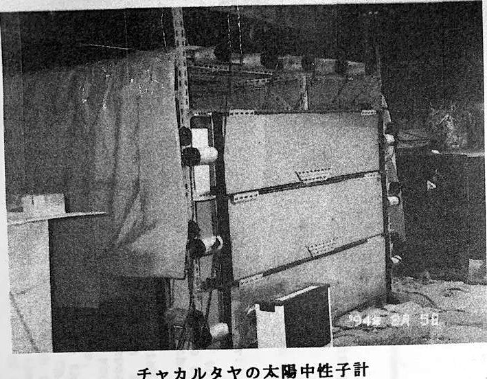
The Bolivian telescope — “Bolivia No. 3” in the Nagoya drawings, after the two at Norikura — was assembled in the spring of 1992 (the installation photographs carry date stamps of April and May 1992) and has taken data since September 1992 and is still measuring today (confirmed by the director, 20 September 2026). It is a block of four plastic scintillators of one square metre and 40 cm thickness — 4 m² in all — surrounded by seventeen anticoincidence scintillators that reject charged particles: a neutron leaves no signal in the outer ring, but on striking a nucleus in the block it produces a proton that does scintillate. Four energy thresholds — 40, 80, 160 and 240 MeV — and proportional counters for direction complete the instrument. According to the Institute's director, it was installed on top of the BASJE muon detector hall, the Rossi hall (communication of 20 September 2026).
With it, and with the 13 m² neutron monitor, the Bolivian group — Pedro Miranda, Nicolás Martinic, Rolando Ticona and Alfonso Velarde — signed with Nagoya the detection of neutrons from the X2.3 flare of 24 November 2000, at 5.5σ, and from the X17 flare of 7 September 2005, with a signal lasting more than twenty minutes. The mountain that saw the π meson in 1947 saw, half a century later, neutrons fresh from the Sun.
The cooperation was formalised in 1994: on 10 March a Nagoya researcher — probably Yasushi Muraki ⚠ — visited Carlos Aguirre, president of the National Academy of Sciences, and on 23 March 1994 Aguirre wrote to the Ambassador of Japan, Shizuya Kato, a letter that runs through half a century of Japanese presence on the mountain — Yukawa, BASJE, Brazil–Japan, SYS — in support of the project. The letter is in the site's archive; the experiment page gathers the Nagoya photographs and drawings.
Aerosols: the first measurement of background pollution
On 15 August 1975 an agreement with the University of Antwerp was signed to measure aerosol particles over La Paz and Chacaltaya.
The analysis, carried out by gas chromatography and mass spectrometry and compared with the city of Antwerp, showed pollution three times lower in Bolivia.
Why it matters more than it seems. It is, as far as the sources reach, the first chemical characterisation of the Bolivian background atmosphere, and it establishes a 1975 baseline against which the measurements the GAW station takes today at the same place can be compared. Fifty years apart at the same point. If those 1975 data can be recovered, the scientific value — and the value for the dossier — is high: see §14.
The rest of the atmospheric line
The site should not turn this into a list, but the dossier does need the complete inventory:
- Ionosphere. Experiments at Ovejuyo and at Cota Cota, with support from the US Bureau of Standards within the International Geophysical Year. Gastón Mejía collaborated. The experiment was later "vainly" attempted to be revived; in August 1975 Bolivia convened the Founding Meeting for the Coordination of Ionospheric Studies, with Argentina, Chile, Colombia, Brazil and Peru, to define a regional project that went on to become a multinational project of the Pan American Institute of Geography and History.
- The equatorial electrojet, studied from the Laboratory within atmospheric physics, and later with the itinerant network of Askania magnetometers whose data were processed by the Carnegie Institution (milestone 08).
- Astrogeology. The Laboratory was a pioneering institution in the study of libration clouds, with José Antonio Zelaya and researchers from the U.S. Geological Survey. It has a section of its own: see §9.
- Solar energy. Taken up again in the 1970s by Israel Saravia and Jaime Guerra, supported by Alberto Arteaga and Guillermo Suxo; the main effort was the design and construction of solar tents and solar heating for dwellings. It descends from Mario Guzmán's first flat-plate solar heater (milestone 08).
- A meteorological satellite tracking station, installed "with little success".
- UNESCO's "Man and the Biosphere" (MAB) programme. The Institute was the seat of the Bolivian Committee, chaired by Carlos Aguirre during a very active period. Aguirre says it opened "the way to later, far more advanced studies and efforts in the field of ecology, the environment and natural resources". It is a second UNESCO programme housed under this roof, in addition to the inter-American seminars of milestone 05.
The Kordylewski dust clouds: the mountain looks at the Moon
Of all the lines of work in this milestone, this is the most unexpected, and the least told.
Between 1962 and 1963 the U.S. Geological Survey attempted to photograph, from Chacaltaya, the "dust clouds" at the Moon's libration points.
9.1 · What those clouds are
The libration points L4 and L5 are two positions on the Moon's orbit, 60° ahead of and 60° behind the Moon, where the Earth's gravity, the Moon's gravity and centrifugal force balance one another. An object placed there tends to stay. The hypothesis was that dust thrown off the Moon by meteorite bombardment might have been trapped in those two gravitational wells, forming two faint clouds.
The Polish astronomer Kazimierz Kordylewski said he had seen them with the naked eye in October 1956 from the Skalnaté Pleso observatory, and photographed them on 6 March and 6 April 1961 from the summit of Kasprowy Wierch. The International Astronomical Union announced the discovery by circular on 23 May 1961. From there began an argument that would run for sixty years.
9.2 · What was done at Chacaltaya
This is where the Laboratory comes in. The clouds, if they exist, are extraordinarily faint objects: they require skies that are dark, dry and high. Chacaltaya had all three.
| Team | E. C. Morris, J. Ring and H. G. Stephens, of the U.S. Geological Survey, together with the Bolivian researcher José Antonio Zelaya |
| How Zelaya came on board | Ismael Escobar, director of the Laboratory in the early 1960s, invited him as an associate researcher |
| Instrument | 6-inch Maksutov-Cassegrain telescope |
| Campaign | From June to November 1963 ⚠ |
| Material obtained | 17 photographic plates of the L4 region and 28 plates of the L5 region |
| Publication | Astrogeologic Studies, Annual Progress Report, August 25, 1962 to July 1, 1963, Part D, U.S. Geological Survey, Open-File Report 64-153, 1964 |
9.3 · What it yielded, and why that is the interesting part
The result was inconclusive. That is how the literature on the Kordylewski dust clouds records it: the U.S. Geological Survey's attempt to photograph them from Chacaltaya, between 1962 and 1963, was not conclusive.
And that is exactly where the value of the episode lies, which is why it should be told in full and without embellishment:
- The clouds were repeatedly denied. Robert Roosen found nothing from McDonald Observatory between 1966 and 1967; neither did Wolff, Dunkelman and Haughney from flights over the Pacific.
- But in 2018 a Hungarian team led by Judit Slíz-Balogh, with Á. Barta and G. Horváth, published polarimetric evidence of the L5 cloud in Monthly Notices of the Royal Astronomical Society; in 2022 it did the same for L4, and in 2024 it observed L5 again from the Khomas Highland in Namibia.
Sixty years later, the search made from this mountain turned out to have been a search for something that exists.
Why this belongs in the dossier, and how it should be told. It is the same pattern as the Centauro event (milestone 07), inverted: there a celebrated finding was later reinterpreted; here an inconclusive observation turned out, decades later, to have been after a real object. The site must not claim that Chacaltaya discovered the Kordylewski dust clouds: it did not, and the report itself says so. It should say something more precise and more interesting: that in 1963 this location was chosen, by another country's geological survey, as one of the few places in the world where the attempt was worth making.
It is also the only episode in the dossier in which Chacaltaya looks not upwards but towards the Moon: an astronomical vocation of the site that appears in none of the ten milestones and that connects with the Planetarium, with Patacamaya and with Santa Ana de Tarija (milestone 08).
9.4 · José Antonio Zelaya
He deserves a sheet of his own, and here are the verified facts.
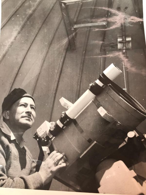
He was born in Chuquisaca on 14 November 1926. He trained in geographical engineering at the Escuela Militar de Ingeniería (Military School of Engineering) and rose to the rank of army general. He qualified as an astronomer through the School of Cartography of the Latin American Geodetic Service and the Pan American Institute of Geography and History. He holds the chair of astronomy at the Academia Nacional de Ciencias de Bolivia (Bolivian National Academy of Sciences), and is one of its longest-standing members. He later directed the Observatorio Astronómico de Santa Ana de Tarija (milestone 08).
A career soldier who ended up as the astronomer of the Academia Nacional de Ciencias, and who in 1963 was photographing the Lagrange points from 5,200 metres. It is one of the most singular biographies in the dossier.
9.5 · The dome
And there is an associated object the dossier ought to locate. Aguirre reproduces a photograph whose caption reads, tersely: "The astronomical dome on the summit of Mount Chacaltaya." A 2019 UMSA note dates the construction of a dome to 1958 ⚠.
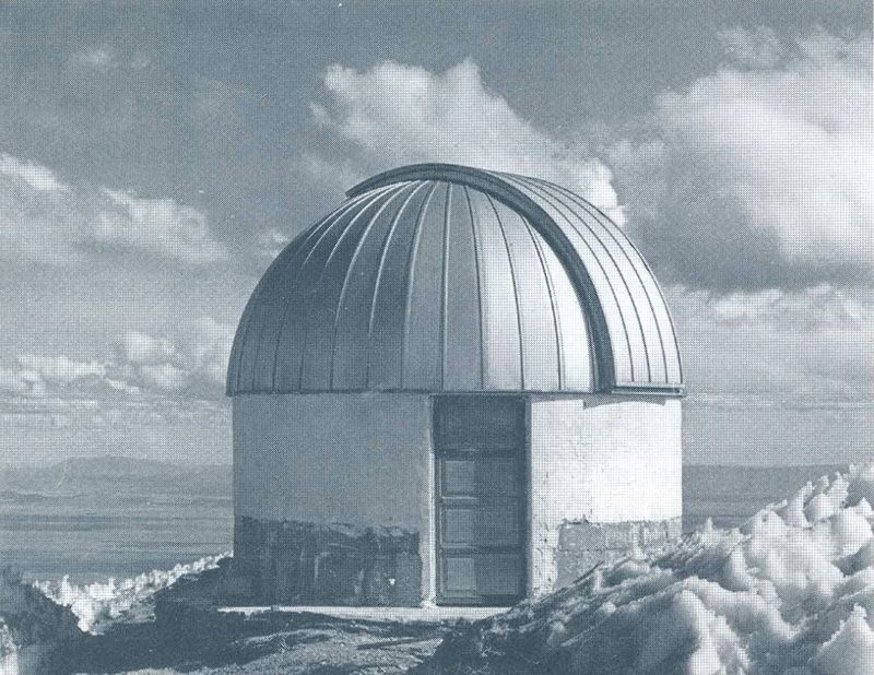
If that dome survives — or if its remains do — it is a material element of the property that is not inventoried today, and the only one that attests to the astronomical vocation of the site. See §15.
The GAW station: the contemporary argument
Here the milestone stops being history.
Since November 2011 ⚠ the Chacaltaya (CHC) Global Atmosphere Watch (GAW) station of the World Meteorological Organization has been operating on the mountain, managed by the Laboratorio de Física de la Atmósfera (LFA, Laboratory of Atmospheric Physics) of UMSA together with the Instituto de Investigaciones Físicas.
| Altitude | 5,240 m a.s.l. |
| Coordinates | 16°21.014′ S · 68°07.886′ W |
| Sampling height | 15 m above the ground |
| Operation | Continuous, seven days a week, with permanent on-site staff |
| Instruments | More than 15 units: CO, CO₂, CH₄, O₃ and SO₂ analysers; aethalometer, nephelometer, mobility spectrometers, LIDAR, automatic weather station |
| Data | Published in validated form on the EBAS platform |
What it measures: greenhouse gases (carbon dioxide and methane), gaseous pollutants (ozone, nitrogen oxides, sulphur dioxide), aerosols — including black carbon — radiation and meteorological variables.
With whom. The international consortium has included, depending on the source and the moment: France (University of Grenoble, LGGE, LSCE, LaMP, OVSQ), Germany (Leibniz Institute for Tropospheric Research, TROPOS), Sweden (Stockholm University), Switzerland (Paul Scherrer Institute), Italy (ISAC), Finland and the United States (NASA Goddard Space Flight Center). The initiative is led by the Universidad Mayor de San Andrés.
Why it matters. The station captures the background atmosphere — the air of the planet far from local sources of pollution — and for that reason it can detect pollution that has travelled great distances. It is "one of only a handful of high-altitude monitoring stations in South America", and one of the very few global high-altitude stations in the world.
The argument, stated plainly. The international scientific community decided, in 2011, that this exact point on Earth was the right place from which to watch the planet's atmosphere. It is the same decision MIT and the University of Tokyo took in 1961, and Lattes and Yukawa in 1962: the exceptional character of the site is not a historical argument, it is a current one, and there is a United Nations institution upholding it today.
LAGO: the other contemporary project
This is worth settling, because the outline of the ten milestones leaves an open discrepancy.
LAGO — Latin American Giant Observatory, formerly Large Aperture GRB Observatory — is a network of water Cherenkov detectors at high-altitude sites across Latin America, devoted to gamma-ray bursts and to solar–terrestrial physics.
The discrepancy is resolved thus: both dates are correct and they refer to different things.
- The LAGO collaboration began in 2005, "as a collaboration between groups from Argentina, Bolivia and Mexico". Bolivia is a founding country.
- The Chacaltaya detectors have been taking data since 2008. There are three Cherenkov detectors: two of 4 m² and one of 2 m².
The collaboration's 2011 paper further describes Chacaltaya as "the highest and older observatory in the world".
The glacier
And here the milestone closes with what the mountain no longer has.
The Chacaltaya glacier disappeared completely in 2009, and it was one of the first tropical glaciers of the Central Andes to vanish. Skiing ended with it: for decades the mountain had been considered the highest ski run in the world, and it was the Bolivian Andean Club that built the road and the hut which made it possible to install the weather station in 1942 (milestone 01).
The close of the milestone, and perhaps of the whole site. The mountain where an actinometer was installed in 1942 to measure solar radiation is the same mountain whose glacier disappeared in 2009, and it is the same mountain where the carbon dioxide of the planet's background atmosphere is measured today.
The instrument and the evidence are in the same place. The site recorded climate change and suffered it. No other argument in the dossier has that shape, and none is as legible to a non-scientific audience.
Chronology of the milestone
| Date | Event |
|---|---|
| September 1942 | The weather station is installed at 5,200 m, measuring solar radiation. The atmospheric series begins (milestone 01). |
| 1943 | The association with the Servicio Meteorológico de Bolivia is consolidated, "the original partner in the scientific adventure". |
| From 1956 | Equipment unrelated to cosmic radiation arrives: Donner Laboratory (solar infrared) and US Naval Research Laboratory (atmospheric radioactivity). |
| 1957 | Ionosphere experiments at Cota Cota with the US Bureau of Standards, within the International Geophysical Year (milestone 08). |
| 13 February 1960 ⚠ | The Chacaltaya instruments detect the first French nuclear explosion in the Sahara. |
| 1960s | Simpson-type neutron monitor and East–West directional telescopes. |
| 1962 | John Bland transistorises the monitor and establishes the seven-day delay in the rise of radioactivity after the nuclear explosions. |
| 22 March 1963 ⚠ | Supreme Decree 06409: the Centro Nacional de Investigaciones de Astrofísica, Aeronomía y Física Aplicada y del Espacio is created. |
| 1958 ⚠ | The astronomical dome is built on the summit. |
| June – November 1963 ⚠ | U.S. Geological Survey campaign to photograph the Kordylewski dust clouds at libration points L4 and L5, with Morris, Ring, Stephens and José Antonio Zelaya. 17 plates of L4 and 28 of L5 with a 6-inch Maksutov-Cassegrain. Inconclusive result. |
| 1964 | Publication in Astrogeologic Studies, the USGS annual report, Part D. |
| 1965 | International Year of the Quiet Sun: observation of atmospheric ozone begins, led by Ramón H. Schulczewski and Fernando Sheriph. |
| 1965 | The Servicio Meteorológico de Bolivia leaves Chacaltaya. Twenty-three years of surface data come to an end. |
| October 1966 | The "Neutron Supermonitor" is installed. |
| 12 November 1966 | Total solar eclipse: ozone profiles and upper-level winds are measured. |
| 1960s | 2,000 radiosonde flights in seven years from Ovejuyo and El Alto. First published profiles of the upper atmosphere over Bolivia. Daily data to the Miami Hurricane Center. |
| 1969–1971 | The ionosphere and ozone projects are closed. The ozone project is transferred to the Bolivian Air Force and closed for good. |
| 1974 | Seguencoma Magnetic Observatory with the Carnegie Institution (milestone 08). |
| 15 August 1975 | Aerosol agreement with the University of Antwerp: Bolivian background pollution proves to be three times lower than that of Antwerp. |
| August 1975 | Founding Meeting for the Coordination of Ionospheric Studies in Bolivia, with six countries. |
| 1970s | The Institute is the seat of the Bolivian Committee of UNESCO's MAB programme. |
| April – September 1992 | Nagoya University installs the solar neutron telescope on top of the Rossi hall; it measures from September. |
| 23 March 1994 | Letter from Carlos Aguirre, president of the National Academy of Sciences, to the Ambassador of Japan Shizuya Kato, in support of the cooperation with Nagoya. |
| 1995 | Ozone and UV Radiation Laboratory. ⚠ Date taken from the outline, to be verified. |
| 2005 | The LAGO collaboration begins, with Bolivia as a founding country alongside Argentina and Mexico. |
| 2008 | The LAGO Cherenkov detectors at Chacaltaya begin taking data. |
| 24 November 2000 | Neutrons from an X2.3 flare detected at Chacaltaya, at 5.5σ (Watanabe et al., 2003). |
| 7 September 2005 | X17 flare: more than twenty minutes of neutron signal in the Chacaltaya telescope and monitor. |
| 2009 | The Chacaltaya glacier disappears. Skiing ends. |
| 2010 | The new international consortium's atmospheric measurements begin. |
| November 2011 ⚠ | The WMO's Global Atmosphere Watch (GAW) station CHC enters operation, at 5,240 m. |
| 2015 | Air quality and pollution are measured from the cabins of the La Paz cable car. ⚠ Documented in the project's press archive; the scientific reference is missing. |
| 2018 – 2024 | A Hungarian team led by Judit Slíz-Balogh publishes polarimetric evidence of the L5 (2018) and L4 (2022) clouds. They exist. |
| Today | The station operates continuously, seven days a week. |
Open points and series to be rescued
This section is, in my view, the most important of the milestone. These are not errata: they are scientific data that existed and that may be in the process of being lost.
⚠ The surface meteorological series 1942–1965. Twenty-three years of measurements at 5,200 metres. Where is it? Search at today's SENAMHI — successor to the Servicio Meteorológico de Bolivia — in the IIF archive, and in the journal Nimbus. If that series is recovered and spliced onto the GAW station's series, Chacaltaya would have one of the longest high-altitude atmospheric series in the world. It is the archive task with the highest potential yield in the whole project.
⚠ The ozone data of 1965–1969, and in particular the measurements from the eclipse of 12 November 1966. Were they published? Where? Aguirre says they "had important repercussions in the international community", which implies a locatable publication.
⚠ The 1975 aerosol data from the agreement with Antwerp. A baseline fifty years old to compare with the current station. Contact the University of Antwerp.
⚠ The upper-atmosphere profiles published from the 2,000 radiosonde flights. In what publication? Are the records preserved?
⚠ The contribution to the World Data Center: which series, from when, under what identifier. It is verifiable and would be a strong piece of evidence.
⚠ The detection of the Sahara explosion: is there a record, a report or a publication? The date of Gerboise Bleue (13 February 1960) is established, but the Bolivian source gives neither date nor reference. Consult the US Naval Research Laboratory.
⚠ Supreme Decree 06409 of 1963 and the fate of the Centre it created. See §8.
⚠ The date of the Ozone and UV Radiation Laboratory (1995 according to the outline) and its relation to the present GAW station.
⚠ November or December 2011 for the GAW station entering operation: the sources disagree. And **exactly since when it has held the category of global station** within GAW, which is not the same as a regional station. Request this from the LFA.
⚠ The dates of the Kordylewski dust cloud campaign do not quite add up. The Planetario Max Schreier poster gives June–November 1963; the international literature speaks of an attempt "from 1962 to 1963"; and a 2019 UMSA note places it in November 1964. On top of that, the USGS report closes on 1 July 1963, so plates taken up to November of that year could not fit into it: either the campaign is earlier, or the last observations appear in the following report (July 1, 1963 to July 1, 1964, Open-File Report 65-5 ⚠). The original report must be consulted to settle this. See §9.
⚠ The USGS report has not been digitised in the Geological Survey's publications repository, which states that it holds no digital version of Open-File Report 64-153. Obtaining Part D is the archive task of this section, and with it the full names and affiliations of Morris, Ring and Stephens.
⚠ The astronomical dome. Date of construction (1958?), exact location, present condition, and whether it survives at all. See §9.5 and §15.
⚠ **The article in the *Revista Boliviana de Física*** (2010, vol. 17, pp. 32–34) cited as a source by the poster: it should be located and what it adds should be verified.
⚠ The altitudes. 5,200 m (Laboratory), 5,240 m (GAW station), 5,270 and 5,280 m (LAGO publications), 5,600 m (the 1943 summit hut). The site should publish a table of altitudes by installation, with sources, rather than repeating a single figure. It is the kind of detail an evaluator checks.
The material element of this milestone
Unlike the others, this milestone has an object that works today: the GAW station, with more than fifteen instruments in continuous operation.
That changes the terms. Here the dossier does not need a conservation plan for a ruin, but rather:
- A description of the current state and operation of the station, with new photographs.
- The relationship between the GAW station and the proposed property: is it inside the perimeter? What protection regime applies to it? An active scientific installation inside a heritage property demands an explicit answer on compatibility of uses.
- A decision on visitor access to the station, and on how the quality of the air being measured is protected — visitor traffic is, literally, contamination in the signal. It is a real tension between outreach and science that the dossier must resolve, not ignore.
- The inventory of historic instruments: does the actinometer survive? the neutron monitor? the radiosonde station? The 1942 weather hut is, if it has been preserved, the oldest object on the site.
- The astronomical dome and the 6-inch Maksutov-Cassegrain telescope of the 1963 campaign: do they survive? This would be the only object attesting to the astronomical vocation of the location (§9).
- The 45 photographic plates of L4 and L5. If they are held at the USGS or in the IIF archive, they are archive material of the first order.
- Photographic documentation of the glacier: historical photographs with skiers and current photographs of the same framing. A comparison of two images is the most eloquent argument this milestone can offer.
The case for the UNESCO nomination
Short form (for the page):
Chacaltaya measured the atmosphere before it measured the cosmos, and it never stopped. From the 1942 actinometer to the WMO's Global Atmosphere Watch station operating today at 5,240 metres, there are eighty years of observation from the same point — on a mountain whose glacier disappeared in 2009.
Developed form (for the dossier):
- A site with a double reading. It records the cosmos and the climate at once, from the same location and for the same physical reason: altitude. Very few scientific sites in the world sustain both readings, and fewer still for eighty years.
- The argument is current, not historical. A United Nations agency — the World Meteorological Organization — maintains a global atmospheric watch station here, operated by UMSA with partners from six or seven countries. The exceptional character of the site is upheld today by an international institution, not only by an account of the past.
- The demonstration is dated. In 1960 the instruments on this mountain detected a French nuclear test on the other side of the Atlantic, and in 1962 the seven-day delay with which that signal reached Bolivia was measured. The site's fitness for watching the planet's atmosphere is not a hypothesis: it was demonstrated sixty-five years ago and is still being exploited.
- Long series, and one recoverable. Twenty-three years of surface meteorological data (1942–1965), decades of neutron monitor data contributing to the World Data Center, an aerosol baseline from 1975, and the GAW series since 2011. If the 1942–1965 series is recovered and spliced on, the site would have one of the longest high-altitude atmospheric series on the planet.
- The site is at once an instrument and evidence of climate change. The glacier disappeared in 2009; the station that measures background CO₂ is on the same mountain. It is the most legible argument in the dossier for a non-specialist audience, and it is literally true.
- And a warning the dossier should take on board. The interruption of the ozone programme between 1969 and 1971 — transferred between air forces and closed for good — shows what is lost when the continuity of an observation site is broken for administrative reasons. Heritage protection is, among other things, protection of the continuity of the series. That is an argument UNESCO understands well.
Sources
- Carlos Aguirre Bastos, Medio siglo de ciencia en Bolivia. El Laboratorio de Física Cósmica de Chacaltaya de la UMSA, Fundación Universitaria Simón I. Patiño, La Paz, 1996 — chapters on the 1950s, 1960s and 1970s.
- "Life in a Global Atmospheric Watch Station: Watching the Air from the Top of the Andes", WMO Bulletin, vol. 75 (1), 19 June 2026.
- Chacaltaya GAW station (LFA–IIF–UMSA), official site:
chacaltaya.edu.bo. - Chacaltaya Observatory, Bolivia (CHC), station record of SNO-IFA / AERIS.
- "Chacaltaya (5240 m) in Bolivia", press release from TROPOS (Leibniz-Institut für Troposphärenforschung), 24 April 2012.
- A. Andrade et al., "First atmospheric observations from the high altitude Chacaltaya GAW station (Bolivia – 5200 m)", EGU General Assembly, 2012.
- H. Salazar et al., "The Large Aperture GRB Observatory", Proceedings of the 32nd ICRC, 2011 — dates of the LAGO collaboration and of the Chacaltaya site.
- Supreme Decree 06409, of 22 March 1963. ⚠ To be located.
- U.S. Geological Survey, Astrogeologic Studies, Annual Progress Report, August 25, 1962, to July 1, 1963, Part D. Open-File Report 64-153, 1964. DOI 10.3133/ofr64153. ⚠ No digital version in the USGS repository.
- "Observatorio astronómico de Chacaltaya. Observación de las 'nubes de polvo' en los puntos de libración L4 y L5 de la luna", poster of the Planetario Max Schreier, Physics degree programme, UMSA, 2019. Project archive:
chacobs.pdf. - Revista Boliviana de Física, 2010, vol. 17, pp. 32–34. ISSN 1562-3823. ⚠ Reference to be completed.
- "Observación espacial desde Chacaltaya contribuyó al viaje del hombre a la Luna", UMSA, 15 July 2019.
- J. Slíz-Balogh, A. Barta and G. Horváth, "Celestial mechanics and polarization optics of the Kordylewski dust cloud in the Earth–Moon Lagrange point L5", Monthly Notices of the Royal Astronomical Society, 2018; and subsequent work on L4 (2022) and on L5 from Namibia (2024).
- K. Kordylewski, Acta Astronomica, 1961; International Astronomical Union circular of 23 May 1961.
- Press clippings on the measurement of air quality from the La Paz cable car: Cambio, El Sol (15 March 2015), El Deber, Opinión (22 March 2015). In the project press archive.
- Nagoya University, Solar-Terrestrial Environment Laboratory (STEL), 国際太陽中性子観測網 · International Solar Neutron Telescope Network – To better understand the Sun, September 2003 — figs. 29–33 (Chacaltaya) and drawings of the Norikura 1, Norikura 2 and Bolivia 3 telescopes. Copy in the IIF archive.
- Carlos Aguirre Bastos, president of the National Academy of Sciences of Bolivia, letter to H. E. Shizuya Kato, Ambassador of Japan, La Paz, 23 March 1994 (English translation, 2 pp.). Copy in the IIF archive.
- K. Watanabe, Y. Muraki, Y. Matsubara, K. Murakami, T. Sako, H. Tsuchiya, S. Masuda, M. Yoshimori, N. Ohmori, P. Miranda, N. Martinic, R. Ticona, A. Velarde, F. Kakimoto, S. Ogio, Y. Tsunesada, H. Tokuno and Y. Shirasaki, “Solar neutron event in association with a large solar flare on 2000 November 24”, The Astrophysical Journal, 2003 (arXiv:astro-ph/0304067).
- K. Watanabe et al. (with P. Miranda, N. Martinic, R. Ticona and A. Velarde), “Physics of ion acceleration in the solar flare on 2005 September 7 determines γ-ray and neutron production”, Advances in Space Research, vol. 44, no. 7, 2009, pp. 789–793. doi:10.1016/j.asr.2009.06.002.
- D. Lopez and Y. Matsubara, “Search for solar neutrons at Mount Chacaltaya associated with M- and X-class flares during the rising period of solar cycle 24”, Earth, Planets and Space, vol. 67, 2015. doi:10.1186/s40623-015-0222-2 — description of the telescope (4 m², four 40 cm scintillators, 17 anticoincidence counters, thresholds from 40 to 240 MeV) and its operation since 1992.
- D. Lopez, Y. Matsubara, Y. Muraki and T. Sako, “Search for solar neutrons during the maximum of solar cycle 24”, PoS (ICRC2015) 115 — the network: Chacaltaya in operation since September 1992.
This site is being built
The Chacaltaya Cosmic Ray Laboratory is a candidate for World Heritage status. If you hold documents, photographs or memories of the Laboratory, the project would like to hear from you.
Get in touch